If you want to know about the objective of design or origin of architecture or principles of design, please click the link.
Site analysis in architecture refers to the evaluation of a specific location or piece of land for its suitability for architectural design and development. It is a crucial step in the architectural design process, as it helps architects understand the physical, environmental, and cultural factors that will shape the design of a building.
- preparing a development application can be a complex process that requires careful consideration of various factors related to the site, including its physical and environmental characteristics, cultural influences, and regulatory requirements.
- The first step is to compile sensible information on the location and therefore the close area, as well as streets, neighborhoods and facilities, soils and geology, topography and drainage, general zoning, partitioning and development policies and standards, easements, vegetation, climate, views and alternative pertinent factors.

A site analysis is a key component of the development application process, as it provides valuable information about the site and its potential for development. This information can then be used to guide the design and development process and ensure that the final proposal is both feasible and compliant with relevant regulations and standards.
Additionally, incorporating information about cultural influences and environmental considerations into the development application helps to ensure that the proposed development is sustainable, respects local traditions and values, and minimizes its impact on the natural environment.
A thorough site analysis will consider factors such as:
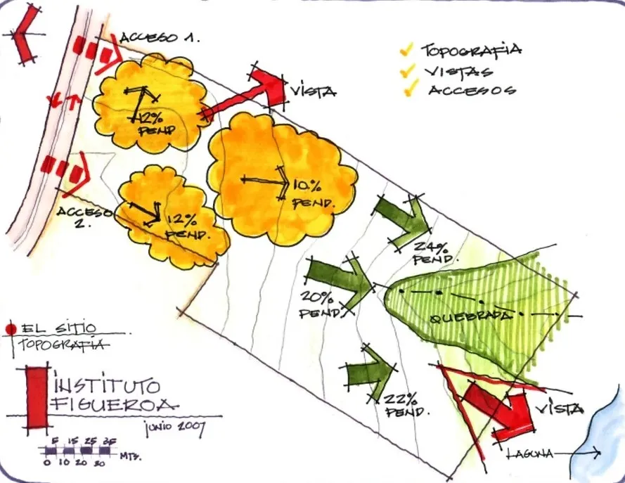
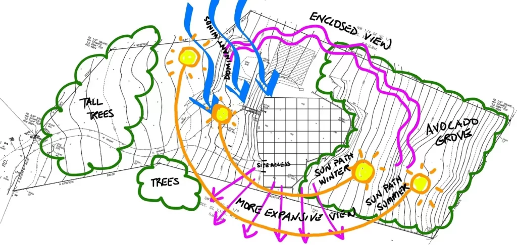
1) Topography analysis
Topography analysis in architecture is the study of the physical characteristics of a site, including its natural features, slope, and elevation. The goal of topography analysis is to understand how the site’s physical characteristics will impact the design of a building and its surrounding landscape.
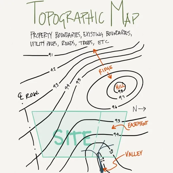
Topography analysis in architecture typically includes the following steps:
- Data Collection: Gathering information about the site’s topography, including maps, aerial photographs, and survey data.
- Site Observation: Visually observing the site to understand its physical characteristics, including its natural features, slope, and elevation.
- Topographic Mapping: Creating a topographic map of the site that accurately represents its physical features, including contours, elevation changes, and areas of slope.
- Slope Analysis: Evaluating the site’s slope and elevation to determine its suitability for the project and identify any areas that may require special attention or modifications.
- Design Integration: Using the information gathered during the topography analysis to inform the design of the building and its surrounding landscape, ensuring that it is responsive to the site’s physical characteristics and its context.
Topography analysis is an important step in the architectural design process, as it helps architects understand the opportunities and constraints of the site, and ensure that the final design is functional, accessible, and aesthetically pleasing.
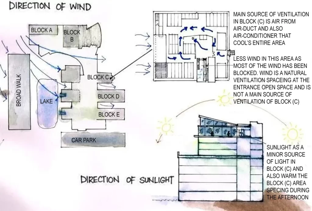
2) Climate analysis
Climate analysis in architecture is the study of the climate conditions and patterns that will impact a building and its surrounding landscape. The goal of climate analysis is to understand how these conditions will influence the design of a building, including its energy consumption, indoor comfort, and materials selection.
Climate analysis in architecture typically includes the following steps:
- Data Collection: Gathering information about the climate conditions of the site, including temperature, precipitation, wind patterns, and solar exposure.
- Climate Zoning: Classifying the site based on its climate conditions and patterns, and evaluating its potential impact on the building and its surroundings.
- Design Integration: Using the information gathered during the climate analysis to inform the design of the building, including its orientation, massing, and fenestration, as well as the selection of materials and systems.
- Energy Efficiency: Evaluating the building’s energy consumption and identifying strategies for reducing its impact on the environment and improving indoor comfort.
- Ongoing Monitoring: Monitoring the building’s performance over time and making any necessary adjustments to improve its energy efficiency and comfort.
Climate analysis is a critical step in the architectural design process, as it helps architects understand the unique climate conditions of the site and design a building that is responsive to those conditions, while minimizing its impact on the environment.
3) Soil conditions analysis
Soil conditions analysis in architecture is the study of the physical and chemical properties of the soil at a particular site. The goal of soil conditions analysis is to understand how the soil will impact the design and construction of a building and its surrounding landscape.

Soil conditions analysis in architecture typically includes the following steps:
- Data Collection: Gathering information about the soil conditions at the site, including its composition, structure, and bearing capacity.
- Soil Sampling: Collecting soil samples from the site to be analyzed in a laboratory, in order to determine its composition, structure, and properties.
- Soil Mapping: Creating a map of the soil conditions at the site, including areas of different soil types and their characteristics.
- Design Integration: Using the information gathered during the soil conditions analysis to inform the design of the building and its foundations, as well as the surrounding landscape.
- Foundation Design: Designing the building’s foundation to accommodate the soil conditions at the site and ensure stability and durability over time.
Soil conditions analysis is an important step in the architectural design process, as it helps architects understand the unique properties of the soil at a site and design a building and its foundation that are responsive to those conditions, while ensuring safety and stability over time.
4) Hydrology analysis
Hydrology analysis in architecture is the study of the water resources and drainage patterns at a particular site. The goal of hydrology analysis is to understand how the water resources and drainage patterns will impact the design and construction of a building and its surrounding landscape.
Hydrology analysis in architecture typically includes the following steps:
- Data Collection: Gathering information about the water resources and drainage patterns at the site, including the location of streams, rivers, and wetlands, and the direction and velocity of water flow.
- Hydrologic Mapping: Creating a map of the hydrologic conditions at the site, including the location of water resources, drainage patterns, and areas of flooding.
- Design Integration: Using the information gathered during the hydrology analysis to inform the design of the building and its surrounding landscape, including the placement of retaining walls, stormwater management systems, and landscaping features.
- Water Management: Designing systems for managing and conserving water resources, such as rainwater harvesting and greywater reuse, to minimize the building’s impact on the surrounding water resources.
Hydrology analysis is an important step in the architectural design process, as it helps architects understand the unique water resources and drainage patterns of a site and design a building and its surrounding landscape that are responsive to those conditions, while minimizing their impact on the environment.
5) Access analysis
Access analysis in architecture is the study of the transportation and mobility patterns that impact a building and its surrounding landscape. The goal of access analysis is to understand how people will move to, from, and within the site, and to design a building and its surrounding landscape that is accessible and convenient for all users.
Access analysis in architecture typically includes the following steps:
- Data Collection: Gathering information about the transportation and mobility patterns at the site, including the location of roads, sidewalks, and public transportation, and the flow of pedestrian and vehicle traffic.
- Access Mapping: Creating a map of the access patterns at the site, including the location of transportation hubs and the flow of pedestrian and vehicle traffic.
- Design Integration: Using the information gathered during the access analysis to inform the design of the building and its surrounding landscape, including the placement of sidewalks, parking, and public transportation access.
- Accessibility: Evaluating the accessibility of the building and its surrounding landscape for all users, including those with disabilities, and making any necessary modifications to ensure that it is accessible and convenient for all.
Access analysis is an important step in the architectural design process, as it helps architects understand the unique transportation and mobility patterns of a site and design a building and its surrounding landscape that are responsive to those conditions, while ensuring accessibility and convenience for all users.
6) Zoning regulations analysis
Zoning regulations analysis in architecture is the study of the local, state, and federal laws and regulations that impact the use and development of a site. The goal of zoning regulations analysis is to understand the restrictions and requirements that apply to a site and to design a building and its surrounding landscape that complies with all relevant regulations.
Zoning regulations analysis in architecture typically includes the following steps:
- Research: Gathering information about the local, state, and federal laws and regulations that apply to the site, including zoning laws, building codes, and environmental regulations.
- Zoning Map Analysis: Reviewing the local zoning map to determine the designated zoning district for the site and the restrictions and requirements that apply.
- Design Integration: Using the information gathered during the zoning regulations analysis to inform the design of the building and its surrounding landscape, including the maximum building height, minimum setbacks, and parking requirements.
- Permit Review: Reviewing the building plans and site design to ensure that they comply with all relevant zoning regulations and obtaining any necessary permits.
Zoning regulations analysis is an important step in the architectural design process, as it helps architects understand the restrictions and requirements that apply to a site and design a building and its surrounding landscape that complies with all relevant regulations, while ensuring that the design is feasible and practical.
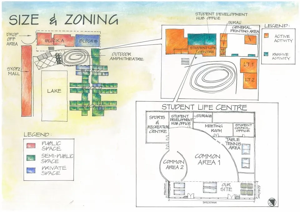
Size and zoning
- Site boundaries is placed by either confirming the dimensions physically.
- Zoning classifications, setbacks, height restrictions, allowable site coverage, uses, and parking necessities are obtained by getting zoning classifications from a zoning map, which might be set from town planning department.
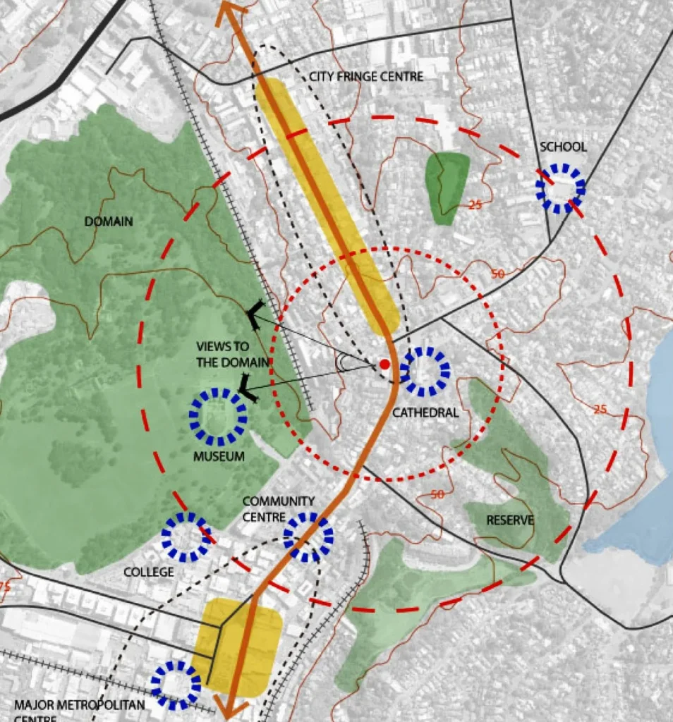
7) Context analysis
Context analysis in architecture is the study of the physical, cultural, and historical context of a site and its surrounding area. The goal of context analysis is to understand how the site and its surroundings will impact the design and construction of a building and its surrounding landscape.
Context analysis in architecture typically includes the following steps:
- Data Collection: Gathering information about the physical, cultural, and historical context of the site and its surrounding area, including the location of existing buildings and structures, cultural landmarks, and historical sites.
- Context Mapping: Creating a map of the context of the site and its surrounding area, including the location of existing buildings and structures, cultural landmarks, and historical sites.
- Design Integration: Using the information gathered during the context analysis to inform the design of the building and its surrounding landscape, including the integration of existing structures, cultural landmarks, and historical sites into the design.
- Contextual Respect: Evaluating the impact of the design on the context of the site and its surrounding area and making any necessary modifications to ensure that it respects the context and enhances the surrounding area.
Context analysis is an important step in the architectural design process, as it helps architects understand the unique context of a site and design a building and its surrounding landscape that are responsive to that context, while respecting and enhancing the surrounding area.
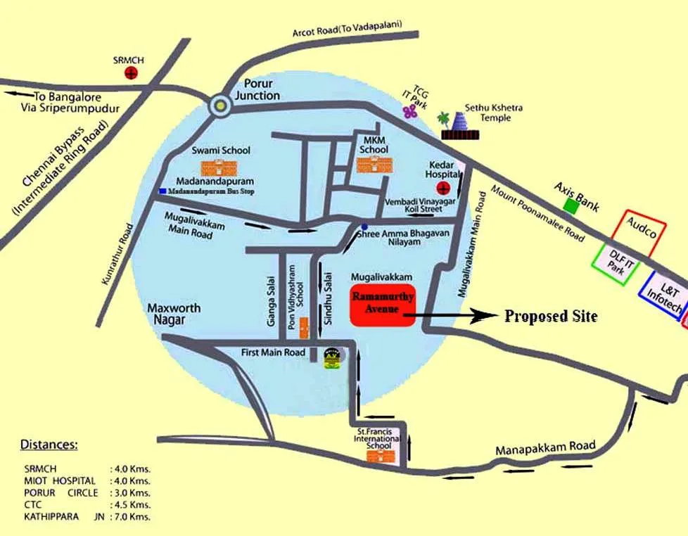
Neighborhood context
- Zoning of the neighborhood is vital, and data of this kind will generally be found at the municipal coming up with department of the positioning.
- Numerous problems at this stage need direct observation. Features of this type of embrace branch of knowledge patterns, street lighting, and condition of existing buildings.
- This would conjointly embrace the immediate surroundings of the positioning.
- The reaction of the surrounding buildings towards the positioning and people traveling ought to be analyzed.
Example
- The range, scale and level of detail of neighborhood conditions investigated inside any neighborhood analysis are going to be obsessed with the scale and complexness of the project, and therefore the scale and significance of anticipated effects.
- When determinative what data has relevancy to your neighborhood analysis, it’s vital to outline the extent of your neighborhood.
- In some instances, this can relate to a suburban area with clear boundaries. If less obvious, a 400m radius circle is used.
- This distance is wide recognized as being the space people can gayly go into order to fulfill their daily desires, and generally equates to a 5 minute walking distance.
- The attributes of a neighborhood will embody landform and natural atmosphere components, predominant street patterns, transport choices and therefore the method people move or travel through it, land uses, designed type character, areas of cultural or historical significance and therefore the over-arching cultural and environmental values of the world.
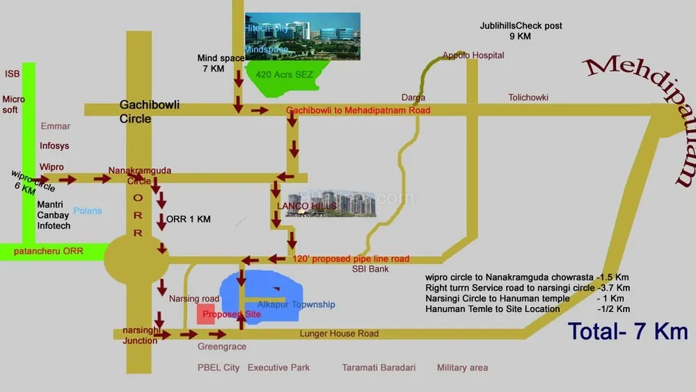
8) Location analysis
Location analysis is a critical step in the architectural design process, as it helps architects identify the best site for a project and ensure that the final design is responsive to the site and its context.
- The site ought to be associated with major streets or landmarks antecedently existing. Aerial images facilitate during this assessment stage.
- There ought to be documentation of distances and time from major places. This could be completed by either driving or walking the space first-hand.
The information gathered through site analysis is used to inform the design of a building and ensure that it integrates seamlessly with its surroundings. The goal is to create a building that is functional, efficient, and responsive to the unique characteristics of the site.