If you want to know about the day lighting or site climate or climatic zones in India, please click the link.
Climate refers to the long-term average of weather conditions, including temperature, precipitation, humidity, wind, atmospheric pressure, and other factors, over a specific region or area. Climate is typically characterized by its average temperature and precipitation, as well as by the frequency and intensity of weather events such as storms, heatwaves, droughts, and floods.
The elements of climate are the factors that contribute to the overall climate conditions of a particular region or area. These elements are interdependent and interact with each other to determine the overall climate conditions of the region.
1) Climate: The given conditions
- Weather is the set of atmospheric conditions prevailing at a given place and time.
- Climate (from Greek: klima) ‘region with certain conditions of temperature, dryness, wind, light, etc. Oxford dictionary
- Climate ‘an integration in time of weather conditions, characteristics of a certain geographical location.’
- At the global level climates are formed by the differential solar heat input and the uniform heat emission over the earth’s surface. The movement of air masses and of moisture-bearing clouds is driven by temperature differentials and strongly influenced by the Coriolis force.
i) Solar radiation quality
- The earth receives almost all the energy form the sun in the form of radiation, thus the sun is the dominating influence on climates. The spectrum of solar radiation extends from 290 to 2300 nm (nanometer = 10-9 m). According to human means of perception we can distinguish:
- ultra-violet radiation 290 to 380 nm, producing photo-chemical effects, bleaching, sunburn, etc.
- visible light 380 (violet) to 700 nm (red).
- Short infra-red radiation, 700 to 2300 nm, radiant heat with some photo-chemical effects.
ii) Solar radiation quantity
- The intensity of radiation reaching the upper surface of the atmosphere is taken as the solar constant 1395 W/m2, which varies ±2% due to variations in the output of the sun itself and ±3.5% due to changes in the earth-sun distance
- The earth moves around the sun in a slightly elliptical orbit- the solar distance is 152 million km at aphelion and 147 km at perihelion.
- One revolution of the earth takes 365 days, 5 hours, 48 minutes and 46 seconds.
iii) Tilt of the earth’s axis
- The earth rotates around its own axis, each rotation making one 24-hour day.
- The axis of this rotation (the line joining the North and South Poles) is tilted to the plane of the elliptical orbit, at an angle of 66.5° (i.e., a tilt of 23.5° from the normal) and the direction of this axis is constant.
- Due to the tilted position, the area receiving the maximum intensity moves north and south, between the tropic of Cancer (latitude 23.5°N) and the tropic of Capricorn (latitude 23.5°S). This is the main cause of seasonal changes.
- On 21 March and 23 September areas along the Equator are normal to the sun’s rays and experience a zenith path of the sun. For all areas of the earth these are the equinox days (day and night of equal length)
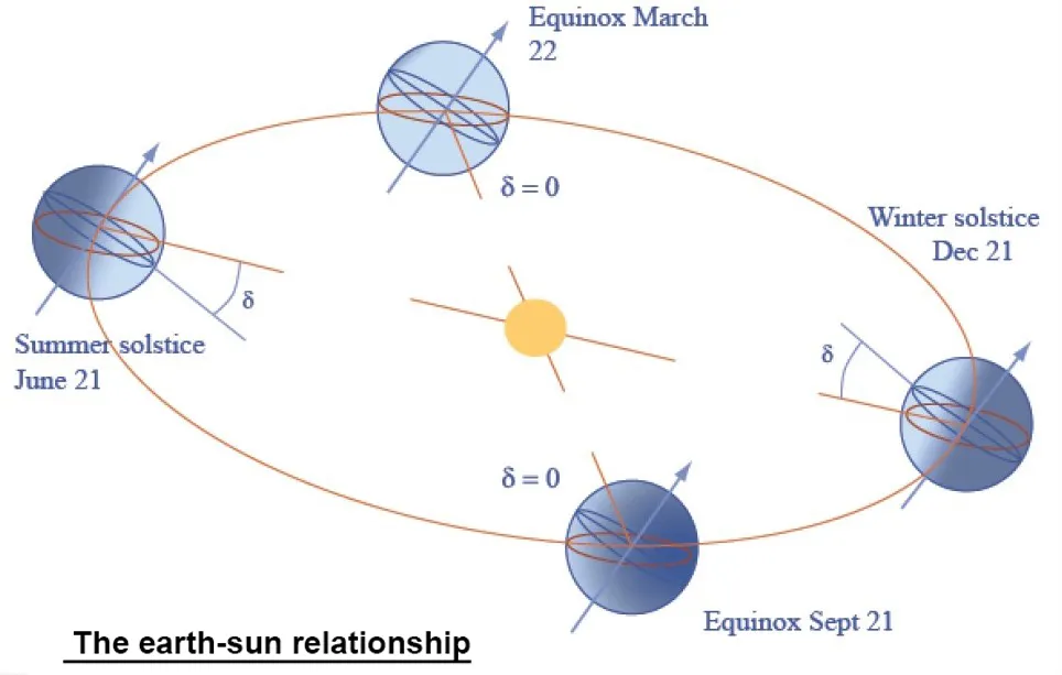
21 June
- Areas along latitude 23.5 N are normal to the sun’s rays – longest daylight – Summer solstice in the Northern hemisphere
- Areas along latitude 23.5 S – shortest day and a radiation minimum – Winter solstice in the Southern hemisphere
21 December
- Areas along latitude 23.5 N – shortest day and a radiation minimum – Winter solstice in the Northern hemisphere
- Areas along latitude 23.5 S are normal to the sun’s rays – longest daylight – Summer solstice in the Southern hemisphere
iv) Radiation at the earth’s surface
This earth-sun relationship affects the amount of radiation received at a particular point on the earth’s surface three ways:
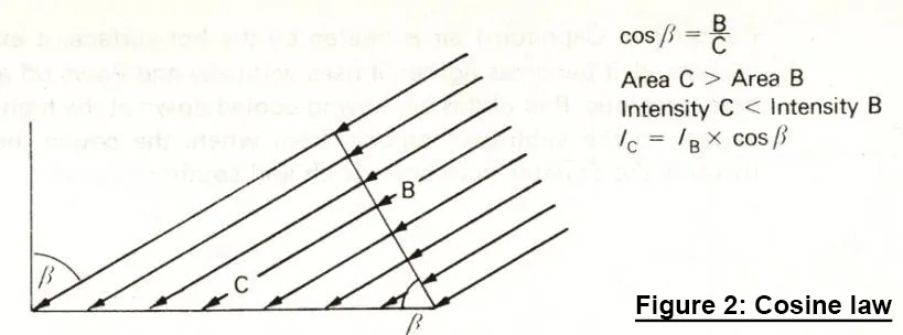
- The cosine law, which states that the intensity on a tilted surface equals the normal intensity times the cosine of the angle of incidence. Figure 2 shows how the same amount of radiation is distributed over a larger area, therefore less radiation falls on unit area.
- Atmospheric depletion, i.e., the absorption of radiation by ozone, vapours and dust particles in the atmosphere (a factor of 0.2 to 0.7).
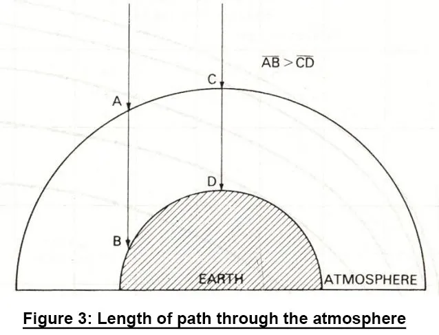
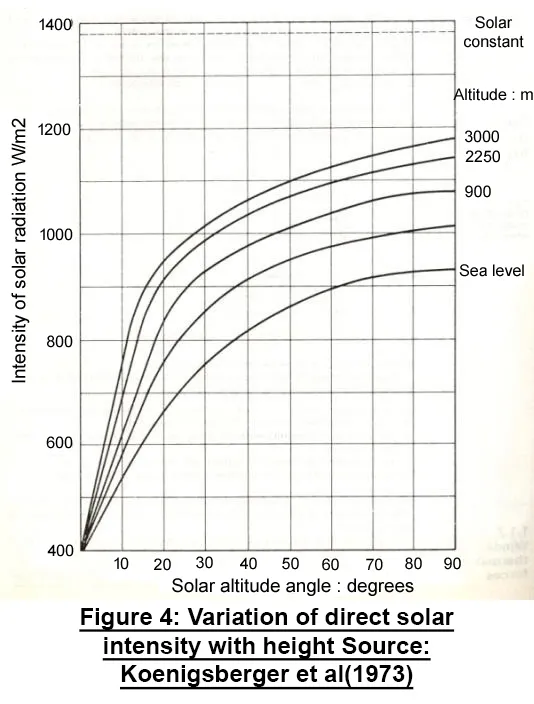
- The lower the solar altitude angle, the loner the Parth of ration through the atmosphere, thus a smaller part reaches the earth’s surface.
- Figure 3 indicates this geometrical relationship and Figure 4 shows this effect in quantitative terms for points at different heights above sea-level.
- This atmospheric depletion is also affected by the momentary state of the atmosphere: its purety, vapour, dust , smoke, etc. content.
- Duration of sunshine, i.e. the length of the daylight period.
v) The earth’s thermal balance
The total amount of heat absorbed by the earth each year is balanced by a corresponding heat loss. Without this cooling the thermal balance of the earth could not be maintained, the temperature of the earth and its atmosphere would increase and would soon cease to be favourable to most forms of life.
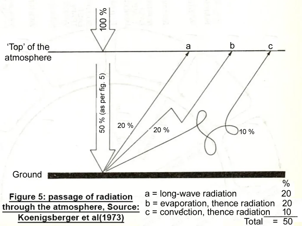
- a. by long-wave radiation to cold outer space (some 84% of this reradiation is absorbed in the atmosphere, only 16% escapes to space)
- b. by long-wave radiation to cold outer surface (some 84% of this reradiation is absorbed in the atmosphere, only 16% escapes to space)
- c. by evaporation: the earth’s surface is cooled, as liquid water changes into vapour and mixes with air
- d. by convection: air heated by contact with the warm earth surface becomes lighter and rises to the upper atmosphere, where it dissipates its heat to space.
2) Winds: thermal forces
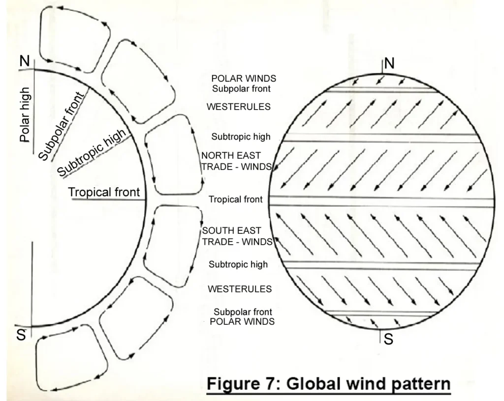
- Winds are basically convection currents in the atmosphere, tending to even out the differential heating of various zones. The pattern of movements is modified by the earth’s rotation.
- At the maximum heating zone (which is somewhere between the tropics of Cancer and Capricorn) air is heated by the hot surface, it expands, its pressure is decreased it becomes lighter, it rises vertically and flows off at a high level towards colder regions.
- Part of this air, having cooled down at the high level, descends to the surface in the subtropic regions, from where the cooler, heavier air is drawn in towards the Equator from both north and south.
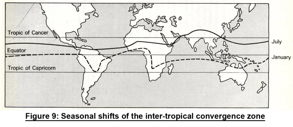
- The area where the air rises, where these northerly and southerly winds meet, where the tropical front is formed, is referred to as the inter-tropical convergence zone (ITCZ).
- This area experiences either completely calm conditions or only very light breezes of irregular directions and is referred to by sailors as ‘doldrums’.
- The global pattern of thermal air movements is shown in Figure 7.
3) Trade-winds: the Coriolis force
- The atmosphere rotates with the earth. As it is light in weight and behaves as fluid, held against the earth’s surface only by gravity and friction, it has a tendency to lag behind the earth’s rate of rotation where this rotation is faster, i.e., at the Equator.
- There is a ‘slippage’ at the boundary layer between the earth and its atmosphere caused by what is known as the ‘Coriolis force’.
- The effect is experienced as a wind blowing in a direction opposite to that of the earth’s rotation.
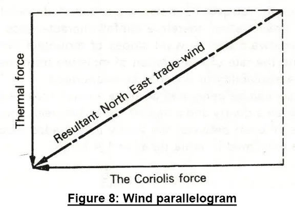
- The actual wind is the resultant of thermal forces and the Coriolis force (Figure 8): north-easterly winds north of the Equator and south-easterlies south of the Equator.
- These are known as Northeast and Sourth East trade-winds, a term originated by round the world traders in the days of sailing-ships.
4) Elements of Climatic
The main climatic elements, regularly measured by meteorological stations, and published in summary form are:
- Temperature – dry-bulb temperature degree Celsius (°C)
- Humidity – expressed as relative humidity (%) or absolute humidity (g/kg or g/m3), or the web-bulb temperature or dew-point temperature may be stated, from which the humidity can be deduced.
- Air movement – both wind speed (m) and direction are indicated, measured with cup-type or propeller anemometer
- Precipitation – the total amount of rain, hail, snow, dew, measured in rain gauges and expressed in mm per unit time (day, month, year).
- Cloud cover – based on visual observation and expressed as a fraction of the sky hemisphere (tenths, or ‘octas’ = eights) covered by clouds.
- Sunshine duration – the period of clear sunshine (when a sharp shadow is cast), measured by a sunshine recorder which burns a trace on a paper strip, expressed as hours per day or month.
- Solar radiation – measured by a pyranometer, on an unobstructed horizontal surface and recorded either as the continuously varying irradiance (W/m2), or through an electronic integrator as irradiance over the hour or day.
i) Classification of Climates
- The motions of Earth in space give rise to periodic climatic, hydrological, biological, and geological events. The changing intensity and duration of solar radiation bring about changes in the atmosphere and seas.
- Many centuries ago, Aristotle proposed the first classification of climate. The Greek word ‘klima’ was defined as the slope of the earth toward the equator so the classification was based on distance from the equator, or latitude. The world was divided into – torrid, temperate and frigid and ancient scholars believed that the ‘klima’ determined the characteristics of the plants, animals and even the people in each zone.
- Vegetation based classification was given by Wladimir Köppen, a German biologist trained in St. Petersburg. This classification was first published in 1900, is still the one most widely used today.
ii) Classification of climate for building design
For the purposes of building design, a simple system based on the nature of the thermal problem in the particular location is often used.
- Cold climates, where the main problem is the lack of heat (under heating), or an excessive heat dissipation for all or most parts of the year.
- Temperate climates, where there is a seasonal variation between underheating and overheating, but neither is very severe.
- Hot-dry (arid) climates, where the main problem is overheating, but the air is dry, so the evaporative cooling mechanism of the body is not restricted. There is usually a large diurnal (day – night) temperature variation.
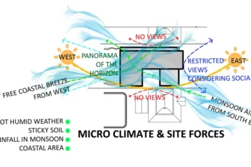
- Warm-humid climates, where the overheating is not as great as in hot-dry areas, but it is aggravated by very high humidities, restricting the evaporation potential. The diurnal temperature variation is small. The general climate (macroclimate) is influenced by the topography, the vegetation and the nature of the environment on a regional scale (mesoclimate) or at a local level within the site itself (microclimate).
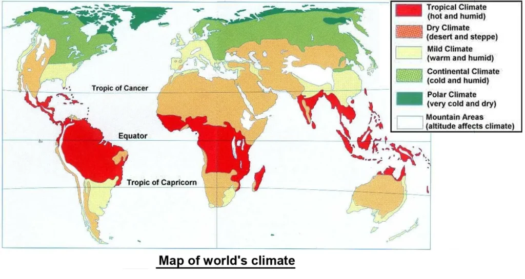
iii) Tropical climates
- Tropical climates are those where heat is the dominant problem, where, for the greater part of the year building serve to keep the occupants cool, rather than warm, where the annual mean temperature is not less than 20°C.
- In general, tropical climates cover a large portion of the Earth’s surface between latitudes 25°N and S.
- In most of this region, temperatures change at least as much from day to night as from summer to winter.
- Radiation intensity is relatively high all year.
- Precipitation defines the climatic regions within the tropics. Between these extremes lie the vast areas with a rainy season and a dry season.
iv) Classification of tropical climates by G. A. Atkinson 1953
- Warm-humid equatorial climates- subgroup warm-humid island or trade-wind climate
- Hot-dry desert, or semi-desert climate- subgroup: hot dry maritime desert climate
- Composite or monsoon climate (combination of 1 and 2)- sub group: tropical upland climate
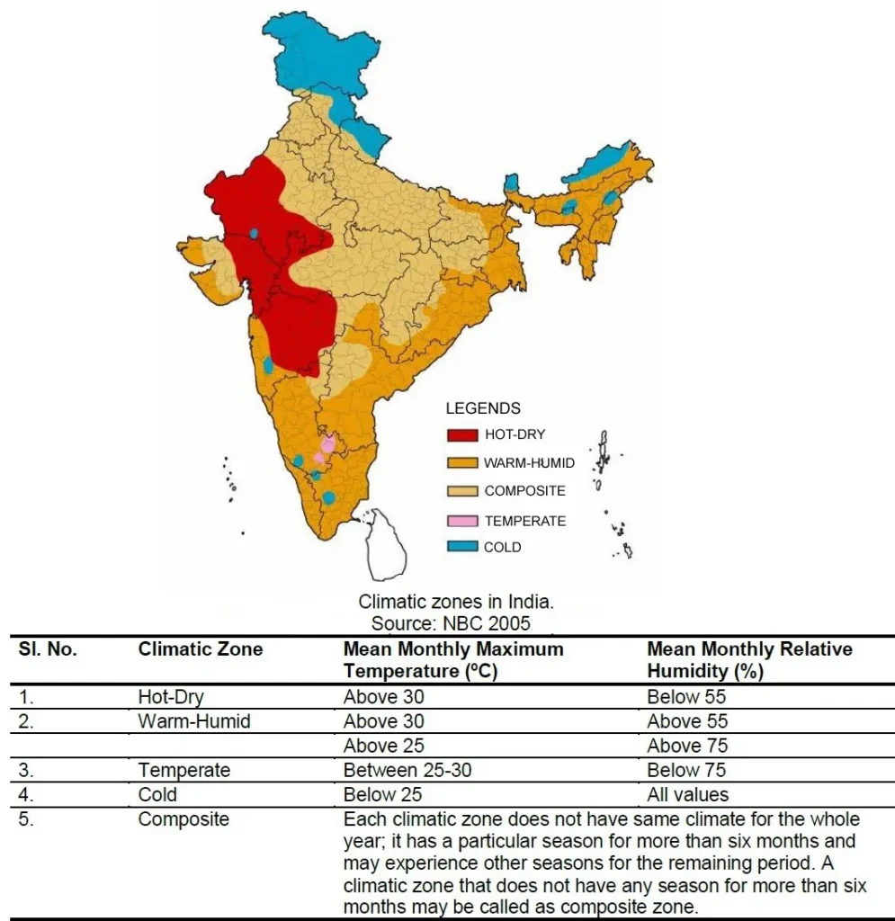
v) Climatic zoning in India
- Latitudinal extent of India is between 6ºN and 36º N
- Longitudinal extent of India between 68ºE and 98ºE
- Total area is about 3.2 million square kilometers
vi) Common climatic elements for building design
- Temperature: – monthly mean of daily maxima (º C) – monthly mean of daily minima (º C)
- Humidity: – early morning relative humidity (%) – early afternoon relative humidity (%)
- Solar radiation: – monthly mean daily total (in Wh/m2)
- Wind: – prevailing wind speed (m/s) and direction
- Rainfall: – monthly total (in mm)
Understanding the elements of climate is important for predicting and managing the impacts of climate change, as well as for developing strategies to adapt to changing weather conditions. By studying the elements of climate, scientists can better understand how changes in one element, such as temperature or precipitation, can affect the other elements and contribute to overall changes in the climate.